Feeds:
Posts
Comments

Posts Tagged ‘Travel’

Ages ago, when the world and I were young, there came a summer when I was just plain fed up.

Nothing had gone well for some time. Dreams had been dashed. Adulthood was daunting. My summertime gig at the local Jewish community center had ended, and I had a week or so before my classes at SF State started up, so there I was, despondent and idle, despairing of my future. I had little—no car, paltry funds, dismal prospects, no girlfriend—but Pax, my friend and housemate, though he was in much the same mental space as I was, had two things I did not.

He had a car, and he had an idea:

Road trip. (more…)

Read Full Post »

(If you’re late to the party, no worries.
Here’s where you can find the posts on the Southbound leg,
and the Northbound legs Part 1, Part 2, & Part 3.)

We were on the last few legs of our road trip, but this one was where we would say farewell to California and to Highway 1. It had been a wonderful road, filled with beauty, expanse, clear skies, wildlife, ocean vistas, wonderful towns, great cities, and a feeling that we were really, truly, quite far away from our everyday lives and the thousand natural shocks that they are heir to. However, before we could say goodbye to that old road, CA-1 had one last trick up its sleeve.

Online maps will tell you that the drive from Gualala to Crescent City will take you five hours and forty-five minutes.

This. Is. A. Lie.

It is 276 miles from Gualala to Crescent City, taking Highway 1 to Leggett and US-101 from there. In five and three-quarter hours, that’s an average of forty-eight miles per hour.

This. Is. A. Damnable. Lie.

You might be able to do it in seven hours, maybe six and a half if you pee into a bottle and don’t even stop for petrol, but the only way you’re going to make it from Gualala to Crescent City in 5.75 hours is if you’re a rally driver on a perfectly dry day with all traffic blocked off and you have a co-driver in the next seat calling out “Right 5 over crest, then Left 2 Tightens 1. Don’t cut. DON’T CUT!”

As with most things Highway 1, time along this road is fluid, but unlike in other areas, where time flies by as your eyes take in the wonderful conjunction of ocean and shore, here it expands, eating up the hours in tick-tock fashion, making you work for every mile.

The last section of CA-1, an inland cut between Rockport and Leggett, is an especially harrying bit of road. You will have to use every lesson CA-1 has taught you up to this point. It will take concentration on the driver’s part, and fortitude for any passengers you’ve cajoled into traveling with you. For my wife, whose superpower is sleeping in any moving vehicle, that section of road proved to be her Kryptonite. Unhappily awake, breathing through gritted teeth, right hand white-knuckling the Jesus bar, left hand clenched and ready, she battled centripetal force and nausea as we ascended, descended, twisted, banked, sped up, braked, and wondered how long this damned bit of road actually was.

And yet, as was every other mile along CA-1, it was gorgeous.

Before we hit that section, though, Highway 1 gave us one last spin along the coast. It took us through Point Arena, with its classic lighthouse and keeper’s domicile out on a cliff-sided outcrop, and then through the town of Elk where—would you believe it?—a herd of elk was grazing in the field just past the community church.

We stopped in Fort Bragg, where there is a famous bit of shoreline called Glass Beach. It is where, from 1949 to 1967, the residents of Fort Bragg dumped their solid scrap: appliances, vehicles, and famously, glass. The metal was carted away, but the glass, broken and shattered, remained, to be washed and polished by the waves of decades. Now, the beach is a curiosity, a mixture of sand, shingle, and myriad bits of glass, all rounded and polished.

If you want to visit Glass Beach, your online map will show you a trail—the Glass Beach Trail—out at the end of Elm Street.

This. Is. Another. Lie.

Technically, there is a “Glass Beach Trail” from the end of Elm Street to the shoreline, but it does not take you to the Glass Beach. It just takes you out to the shoreline somewhere north of Glass Beach.

While my wife rested in the car, I walked the Glass Beach Trail three times, sure I was missing something crucial. I walked it once, hit the shoreline, saw no Glass Beach, searched for some—any—signage, and finding none, returned to the trailhead. I tried a second time, wandering a bit north of the trail’s end, looking for a clue. Back at the trailhead, I found the “You Are Here” map and checked it. Glass Beach was a dot a tiny bit south of the trail end, with a staircase to descend the cliffside to the shore. I walked it again and wandered south. Still, no signs, no staircase, no Glass Beach. It was a beautiful walk, and a stunning section of coastline, but if you go, know that the actual Glass Beach is a quarter mile south of the end of the quarter-mile long Glass Beach Trail, and there are no signs directing you to your goal. After my third failed attempt, I’d burned too much daylight walking and head-scratching to allow for another mile’s walk, round trip, on sandy bluffs, so I abandoned the effort and we pressed on.

I wish we’d planned more time on this last section of the trip. Even one more day would have made it much more enjoyable, much less “under the gun.” However, I’d been duped by Google’s 5.75 hour drive-time “estimate,” which I took at face value, and we were committed to our itinerary (and our now non-refundable reservations).

We survived our last battle with CA-1 and connected with US-101 at Leggett. Wider, smoother, straighter, US-101 took us inland along the Eel River, through the majesty of the ancient redwood forests, and past natural wonders like Avenue of the Giants, the Drive-Thru Tree, and Trees of Mystery (actually, worth the visit), as well as more gimmicky roadside attractions selling evidence of Bigfoot and touting encounters with some sort of mysterious “vortex.”

We did make it to Crescent City before the sun set, albeit barely. We had a few more days on the road, but those were more to visit friends than to enjoy the scenery, so this was, in essence, the end of our road trip. From here, we’d go to Lincoln City and Portland before heading home to Seattle.

By the end, we would have traveled over two thousand miles. My online map tells me it is a forty-hour drive.

This. Is. A. Lie.

k

Read Full Post »

(If you’re late to the party, no worries.
Here’s where you can find the posts on the Southbound leg,
and the Northbound legs Part 1 and Part 2.)

At this point, if I as a newly-minted sixty-something had learned anything, it was . . . well . . . that I was sixty-something.

In my early years, I could hop in the car and drive for days. Thousands of miles. Little to no sleep. Who needs motels? Just pull over, push the seat back, and catch a few winks. Dead simple. I once traveled 3,000 miles in six days on a whirlwind tour of the American Southwest, looping from San Francisco to San Diego to Tuscon to Canyon de Chelly to the Grand Canyon to Zion National Park to Las Vegas to Death Valley to Yosemite and back home, all in a two-cylinder Honda car with a dodgy clutch. Easy peasy. No sweat. (Okay, there was a lot of sweat—it was the desert—but you get my drift.)

But after our day of rest and exploration in San Francisco, as we were packing up for the next northbound leg, I had a revelation: I don’t like road trips as much anymore, at least not the kind where you drive all day, bed down for the night, get up, and do it all again. I’m much more into quality these days, not quantity. I don’t want to see as much as I can; I want to see what I see as fully as I can.

And that’s a big difference.

It’s not that I wasn’t enjoying the trip—I was enjoying it a lot—it’s just that I felt rushed, pushed, even cheated by our own itinerary. I was seeing so much, but didn’t have the time for that “deep dive” into the place, the people, the culture, the habits, the smells, sounds, and tastes of wherever we were when the car came to rest for the night.

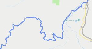
However, lessons learned notwithstanding, today we were on a schedule, and our next stop was a fair ways up the coast.

What’s That Name Again?

Gualala.

Say it with me. Gualala. Gwah-LAH-lah. Fun, right? Well, after twelve hundred miles, we were a bit road-punchy, and we thought it was hilarious. Anyway . . .

Gualala is a little town—technically, not even a town, but an “unincorporated community”—on the Mendocino Coast. Back in high school, when my friend and I used to ride our bicycles up from San Rafael to the cabin his family had in Anchor Bay, Gualala was the town we called “Almost There.” It’s a tiny burg of two thousand souls situated at the mouth of the Gualala River (from the Pomo phrase for “coming down water place”). There’s not much to it: a couple of markets, a gas station, a hotel, a land office or two, some B&Bs, and dozens of homes perched over (or at least in view of) the magnificent rocky coast. Essentially, it’s either a retreat, or a place to pass through.

Or, in our case, to stop for the night.

History Revisited

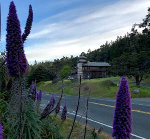
Thirty-six years ago, on our honeymoon, my wife and I spent a week at that same cabin my friend had up in Anchor Bay, and as we passed through Gualala, my bride (through her Dramamine-induced torpor) pointed out her window and said, “Wha tha?” I looked at where she was sort-of pointing, and saw an unusual building. I had ridden by it many times on my cycling trips but, as it was Gualala and we were “Almost There,” I’d never given it much attention. (In my defense, after a 100-mile bicycle ride, one begins to lose interest in the scenery.) This time, though, being in a car and not on a fifteen-speed touring cycle, I slowed down and looked more closely.

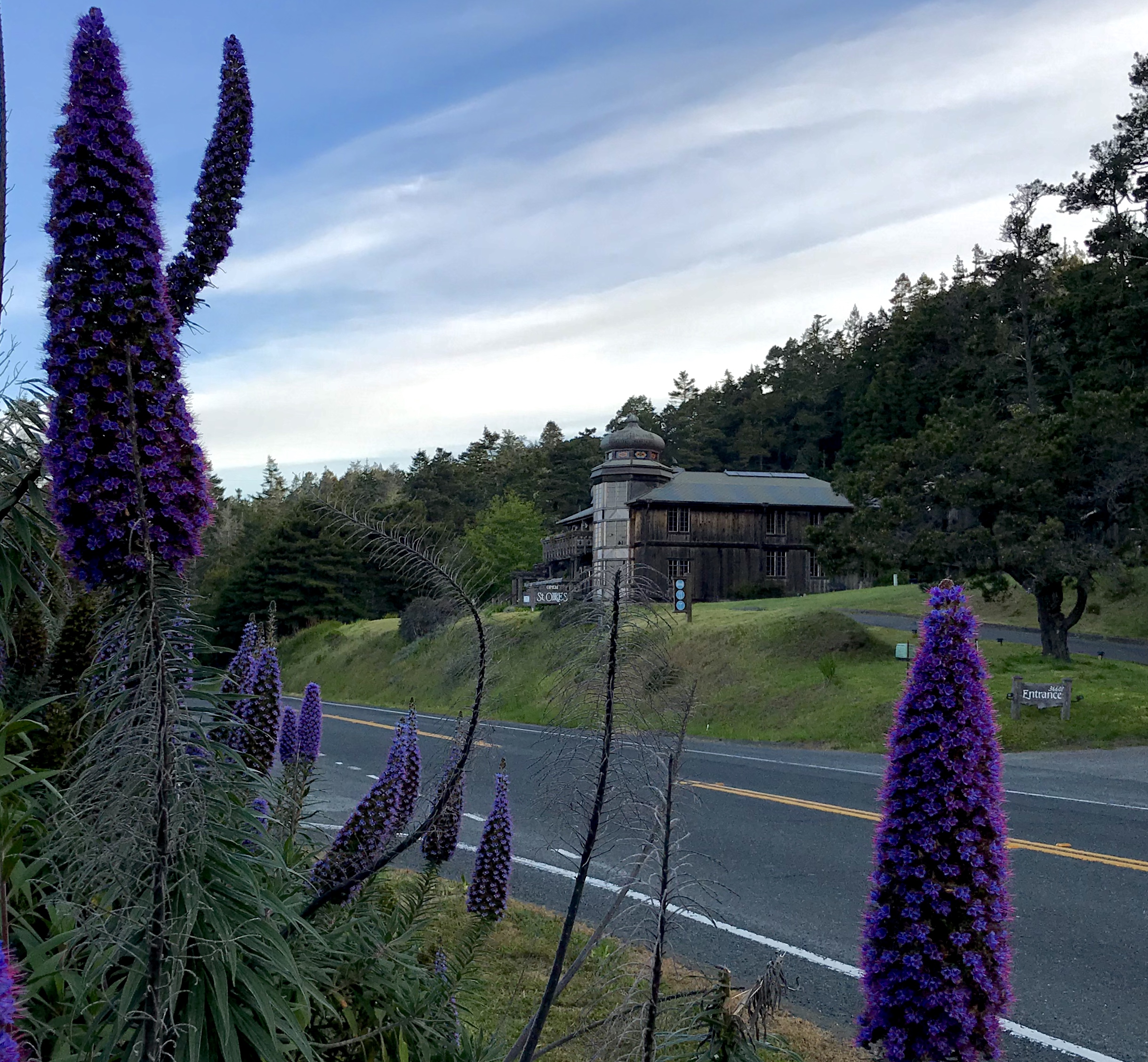
Built of dark, sun-scorched, unfinished wood, with turrets and onion-dome cupolas, it was a hotel/restaurant called St. Orres. While it was unique, beautiful, and rather interesting, this was my honeymoon and I had other things on my mind than inquiring further, so I tucked it away in my brain for future reference.

For our first anniversary, I remembered St. Orres and inquired. They had rooms with shared baths, and cottages for a more private getaway. I rented the best we could afford, which was two nights in their cheapest private cottage. It was wonderful and quirky and very 1980s California, with a small sitting room, a loft bed, bats chirping in the eaves, and an outdoor shower overlooking the coast.

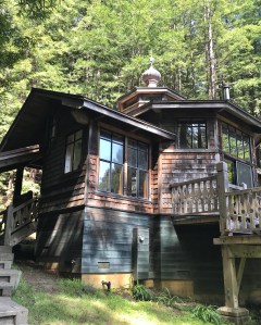
With that as prologue, you can imagine that when I was planning this road trip (I’m the detail-guy, when it comes to itineraries), the realization that we’d be going back past St. Orres set off alerts in my brain. Were they still there? The interwebs answered: they were, and not only that, they had expanded a bit, too. How could we not go back? Having gotten into the “almost top drawer” groove, we opted for the room they called Black Chanterelle. When we checked in, I mentioned to the host that our last stay had been in The Wildflower cottage. “You’re going from the doghouse to the penthouse, then!” she told us, and she was right.

Unlike The Wildflower cottage of our previous stay, which was a simple one-gable affair, this place was built along the same designs as the main buildings: onion dome cupola, hand-fitted tongue-and-groove panels, massive redwood beams, airy, bright, and clean. It was sumptuous, but in a very Arts and Crafts style manner, where all the quality and expense was in the workmanship and raw materials, not in gold and filigree.

Sadly, the restaurant (which we remembered fondly for its stupendous food) was closed on Mondays, and this was a Monday. Since Gualala isn’t known as a foodie mecca, once again we opted for a bread, cheese, and wine dinner. We fired up the wood-burning stove, opened the doors to let in the birdsong, and enjoyed the serenity. In retrospect, seeing as we only had one night in that wonderful place, I’m glad the restaurant was closed.

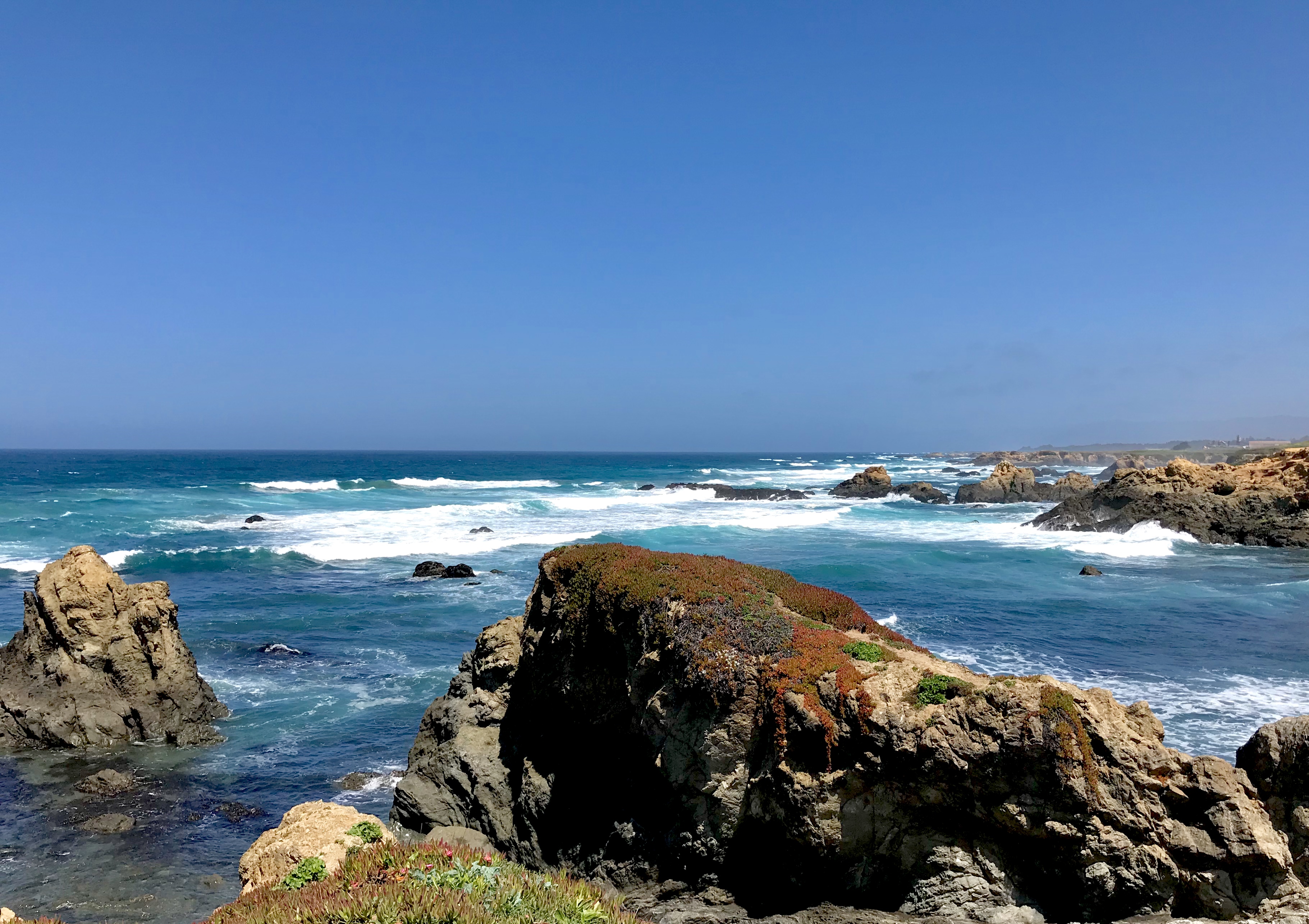
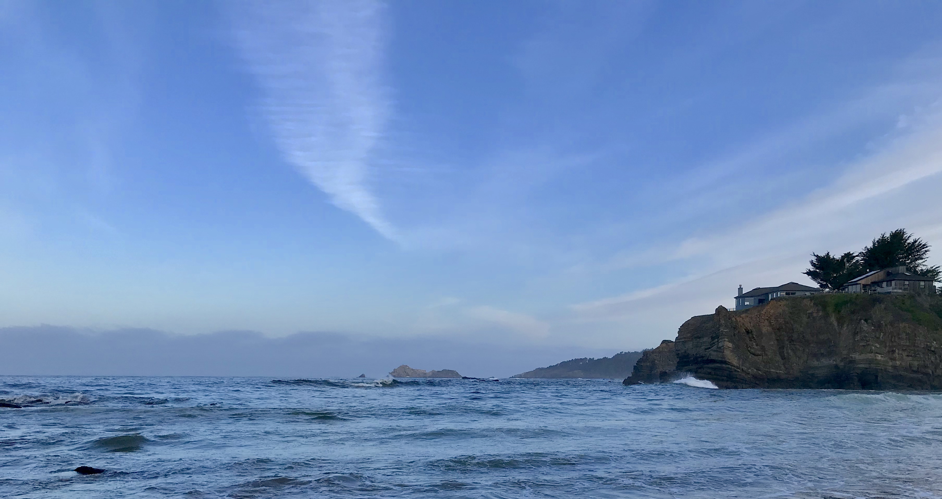
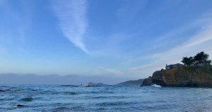
In the morning, I was up at dawn and decided to give my wife another hour of sleep while I went to explore the local beach. A short walk down to the road and a block along the highway brought me to the stairs and the trail down to a cove called Cooks Beach. It’s a small, sandy beach about the size of a football field, ringed by cliffs on which rest the aeries of the well-to-do. A creek tumbles down along the northern edge, and the place is littered with driftwood waiting to be stacked, and bracketed by rocky outcrops that await a beachcomber’s interest. It is a secluded and peaceful spot, where you will only find one or two other folks who have come down for a quiet moment by the ocean.

I’d be hard pressed to pick a favorite, between the quirky Art Deco motel in San Francisco and the masterful craft of St Orres, so I won’t. They’re too different—one urban, one rustic—and too wonderful, each in its own way.

We left, wishing for more, and vowing that it would not be another thirty-five years before we returned.

And the last two legs of our trip were going to be much more demanding, of time, and of stamina.

More later.

k

Read Full Post »

While the first section of our road trip north was one of discovery, the second section was focused on re-discovery.

My wife spent most of her youth in San Luis Obispo, down near where we started our northbound trek, but I grew up near San Francisco, as a fourth-generation resident of Marin County. I was born in San Rafael (the heart of “I Want It All Now” country), and received most of my education in Marin and San Francisco. My wife and I met in Marin, backstage at the ballet company where we both danced, and I courted her on from sides of the Golden Gate Bridge.

Since our wedding, though, we hadn’t spent any time in San Francisco, other than to pass through en route to see family. Thus, as part of this just-for-us quasi-top-drawer road trip, a few days spent in our old stomping grounds was a must. It was in scheduling this stay that I learned that my wife had never taken a ride on a cable car. You know how it is; you never do the touristy things in your own town, right? Well, now we were the tourists, and I was going to make damned sure she got her cable car ride. (more…)

Read Full Post »

Driving the California coast on Highway 1 comes with challenges.

For most of its length, CA-1 is a narrow, undivided, two-lane road that climbs and descends as the topography demands (sometimes rapidly), hugging the often precipitous coastline with switchbacks, hairpins, and a gazillion good old twists and turns. Negotiating these requires a fair bit of concentration, especially when you’ve already put hours of them behind you, and still have hours of them to go. As hard as it is on the driver, though, it’s even harder on the passengers, as they end up as little more than ballast, tossed from side to side like Kirk and Spock on the bridge of the Enterprise during a Klingon attack. While I spent about 80% of my brain power trying to achieve the optimum balance between minimizing the turn-induced, stomach-sloshing G-forces and maximizing our velocity so that we might get to the hotel by the end of check-in time, my wife, whose superpower is the ability to sleep in damned near any moving conveyance, spent several nausea-limned hours regretting our decision to take this route.

Fortunately, the California coast provides ample excuses to pull over, give one’s innards a rest,  and enjoy the scenery. We found the first excuse fairly quickly. (more…)

Read Full Post »

The last time my wife and I took a really-for-real out-of-state vacation was about eight years ago, so when she said she wanted to visit her brother down on the coast of California, we decided to turn it into a road trip. We’d skedaddle down I-5 to Morro Bay, her brother’s town, and then toodle back up along the coast.

Now, I-5 isn’t the most scintillating of avenues; basically, it follows the path of least resistance from Tijuana, Mexico to Vancouver, Canada, and is about as picturesque as as that description would lead you to believe. But it is an extremely efficient pathway for north-south travel, making up for what it lacks in overall beauty with unfettered miles, wide lanes, frequent rest areas, convenient off-on access, and plentiful refueling options of both food and petrol.

The coastal path, following California Highway 1 and then US 101, is the exact opposite. This is a narrow, twisted, gnarled mare’s nest of usually two-lane undivided roadway beset by rockfalls and landslides. Towns are small, strewn hither and yon like lost beads from a broken necklace, and often accompanied by signs saying “NO SERVICES NEXT 45 MILES.” But it is a gorgeous trip, taking you through micro-climates of desert and rain forest, alongside sandy beaches and sundered, rocky cliffs that, quite literally, take your breath.

But before we could get to the pretty part, we had to pass through the gantlet of I-5.

Seasonal Fast Forward

Traveling south from Seattle along I-5 in April was like a time-travel jaunt through the seasons. At home, my lawn was just waking up and the trees were still in flower and bud, but even as we hit central Washington things began to change. It wasn’t long until it seemed like we were in May, then June. The grasses on the hills were a patchwork of acid- and DayGlo-green. Trees were almost in full leaf, and the summertime wildflowers painted the roadside slopes with swaths of orange poppies, yellow buttercups, and purple bush lupines. My eyes, which for the past month had been swollen and painfully dry from dust storms of tree pollen, began to feel once more like part of my body rather than sand-encrusted stones.

The temperatures rose as well. Even as we climbed into the Siskiyous, the mountains that separate Oregon and California, the temps rose up into the 80s (25–30°C), and then as we descended the southern slopes, it got even hotter, into the 90s. What the hell? This is April! It finally hit 98°F (37°C) when we dropped down from the pass and into the high chaparral of northern California.

With temps like that, it was surprising to see Mount Shasta covered with snow, and Lake Shasta (a major reservoir) full nearly to the brim. In all the trips I’ve taken past that lake, it has never been as full as it was this time, and a good thing, too, as it means the poor folks of NoCal might have an easier time this year with wildfires.

And it was right after that, right after we’d passed Shasta (mountain and lake) that the terrain went from deep summer to hellish.

The countryside was scarred by the remnants of the massive wildfires that ravaged the landscape and razed entire towns last fall. California burns every year, but 2018 was brutal. Entire mountains were denuded of green, and square miles had been burnt down to the bare earth. The ridgelines, normally blanketed with thick coniferous forests, had nothing but charred treetrunks that looked like scorched toothpicks on an overdone roast. And road crews were at work everywhere, staking down straw-filled burlap tubes along hillsides to act as bulwarks against the erosion that was sure to come, and laying crushed rock to stabilize the oven-baked slopes that had already started to slip.

Travels Without Charlie

Past the devastation of the fires, we dropped down out of the mountains and hit the central valleys of California, a long slog through flat croplands filled with orchards, dust, heat, and pain. The temps were still unbearably hot for our well-watered Seattle constitutions, but our little car’s A/C kept us refrigerated. We had to say goodbye to I-5 and head to the section of US 101 that would lead us through the Salinas Valley—Steinbeck country—but before we could do that we had to jockey through I-505 and I-680, a nerve-wracking series of meandering, narrow-laned roadways where the trailer-tractors outnumbered cars ten-to-one, where car wrecks and construction zones popped up around every blind curve, and where the faster, far left lanes were owned by “FasTrak,” which protected them with dire warnings of punishments bordering on disintegration should any mortal dare to enter into them without first setting your FasTrak Flex toll tag to position (2) or (3+). Insofar as we did not know what a FasTrak Flex toll tag was (much less have one), we stayed in our plebeian lanes, surrounded by monstrous eighteen-wheeled cargo carriers, until we finally connected with southbound US 101 near San Jose.

The air outside was now 100°F, and we dared not open the windows for fear of incineration. And yet, as we passed through the valley, banked on either side by coastal mountains, filled from one edge to the other with cropland, we saw men and women out there, working, backs bent, skin and clothes the color of dust, hoodies pulled up as protection from the sun that blazed down from what, in any normal place, would be called high summer, but which here was only the early spring of late April in California. We passed buses filled with migrant workers and towing trailers with porta-potties, the better to get more work with less down-time. Towns, low-slung and tired, poked their gabled heads up over highway embankments, hoping for some commerce, even if it was only that we stop for gas and a Coke. Everything seemed broken, age-old, built from cast-off and re-purposed parts, and I envied nothing in that entire valley.

At the bottom, where the mountains encroached, narrowing the vale, the crop changed from vegetable- to petroleum-based. Here the flatland was ruled by the wide, squat cylinders of storage tanks, hubs of arterial webs of pipes, valves, and railroad spurs, all set amidst forests of pumpjacks, those drinking-bird styled machines that bring crude up from the depths.

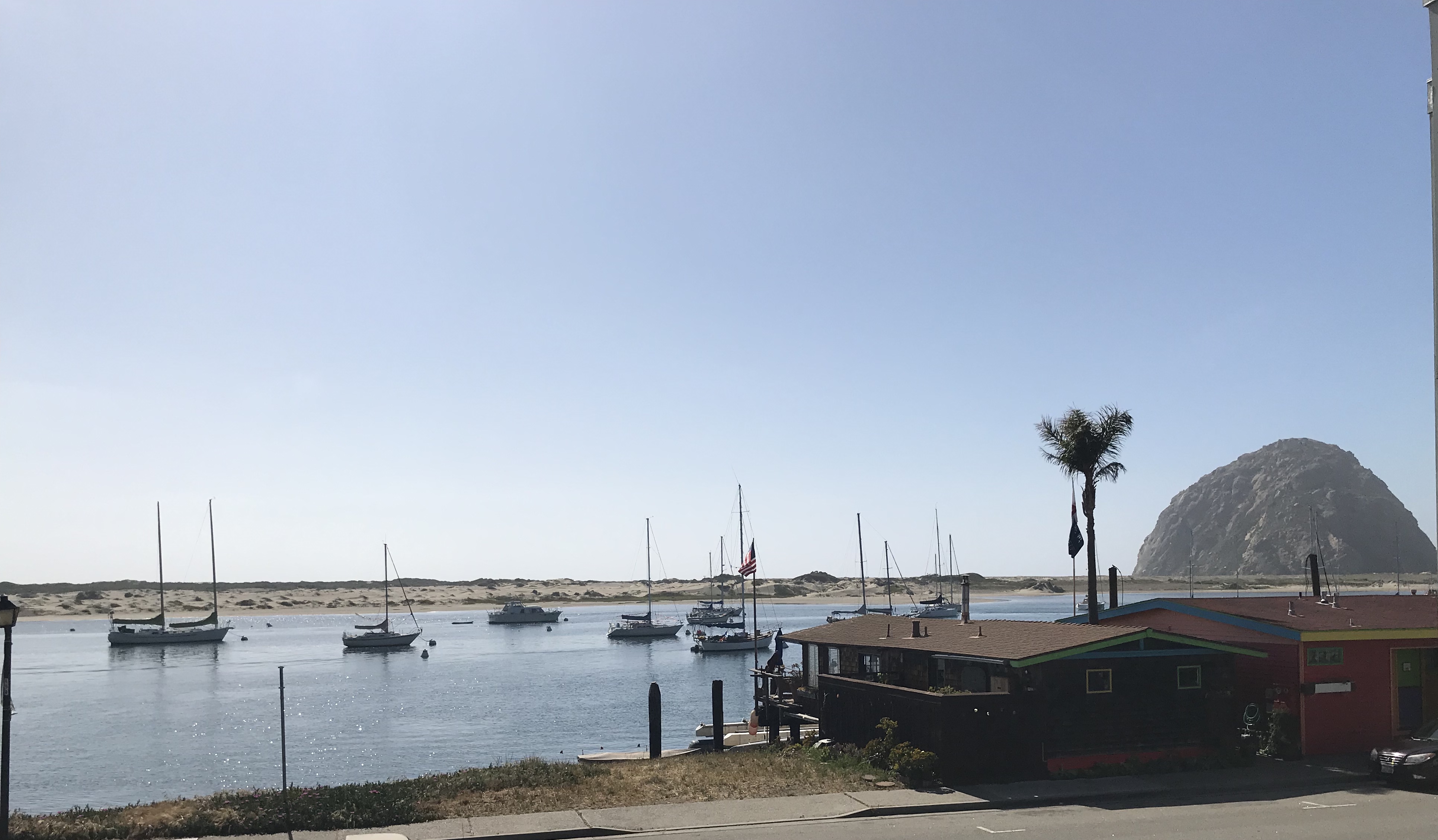
A right turn at Atascadero led us into a narrow ravine, which became a defile, which dropped down to follow an old creekbed through bends and hairpins, where the knee-high grasses leaned out over the tarmacadam and lichenous oaks waved ghostly scarves of Spanish moss above our heads. Within a mile, the temperature dropped twenty degrees. Within three miles, it had dropped another ten. Lush, green, moist, it was a hidden Eden betwixt Hell and the Pacific Coast. The track debouched without warning or omen onto the Coast Highway, and we had arrived at Morro Bay, a town named for a rock that looked to the Spaniards like a nose (morro, Sp. “nose”).

Tired, buzzing from the rumble of the road, the southbound portion of our trip—the hard part, we hoped—was done, and now we could begin to enjoy the journey.

More on that, later.

k

Read Full Post »

Across the Sound there is a place where, when the day is young, I can walk the forest trail and emerge, my shins wet from wading through ferns heavy with dew, and climb the concrete steps to ramparts set high atop a bluff overlooking the steel-grey waters of the Salish Sea. (more…)

Read Full Post »

Older Posts »